 |
| The Rainbow Bridge and American Falls taken from the Skylon Tower on a very cold and windy day. The wind was so wicked out on the viewing area I had to brace myself against something solid. As you can see from the rest of the photographs it was not the best of days. Thes are all colour photographs. |

 |
| The American Falls taken from the Skylon Tower. |

 |
| The Horseshoe Falls taken from the Skylon Tower |
 |
| The Horseshoe Falls taken form the Niagara Parkway. |


 |
This Websters fall from the top, Spencers creek flows through this gorge and actually goes over another falls about 700 metres further down the creek.
|
 |
Websters falls on the Niagara Penninsula, on of many falls along the Bruce Trail. You can just see the rainbow on the right side of the picture. I had to wait for quite awhile for people to move out of my view and as you can see from the surrounding rocks that I was about to get wet.
|

This is a panorama taken from Skyloft ski resort, looking south-east, Chalk Lake is visible in the center of the picture. The picture below is taken from the same spot but shows more to the north. Skyloft is the highest point in the Oakridge Morraine.
  |
Halls Lake in the Algonquin Highlands. This is taken from the highway using the guard rail as a tripod. The light was fading fast as sunset was approaching. This picture was taken looking south-east.
|
 |
This is Halls Lake in the Algonquin Highlands, taken just as the sun was setting. This is the view looking south-east. The picture above is an extension of this one to the right.
|
 |
Chalk Lake is a spring fed lake located north of Ashburn. This was a favourite hangout for us in out teenage years. Today the lake in surounded by houses and in not accessible by the public. I managed to get this picture on a lot were the house was under construction.
|
 |
This pond is in the Enniskillen Conservation Area, and is the spot where I took most of my dragonfly pictures. This is taken with an 8mm Fisheye lens.
|
 |
This is taken from the Skyloft ski resort just north of Ashburn. You are looking south towards Lake Ontario.
|
 |
| The Toronto Skyline taken from Polson Pier. |
 |
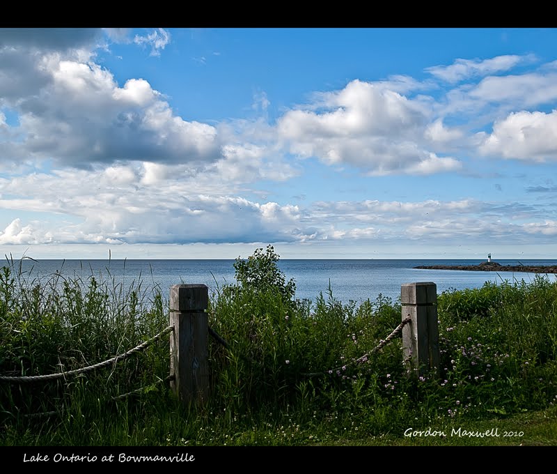
| Lake Ontario Sunrise Oct 18, 2010 from the beach at Bowmanville. |
 |
Walking the dog at Long Sault conservation area. The carpet of falllen leaves and the lighting through the trees caught my attention.
|
 |
This is Buttermilk Falls in the Haliburton Highlands. This is framed by the roots of a downed tree.
|
 |
This is Buttermilk Falls located north of Carnarvon in the Haliburton Highlands. The falls drain into Boshkung Lake. This is taken just at the end of the spillway.
|
 |
This is one of the ponds in Colonel Danforth Park, part of the Rouge Valley area. When I was composing this shot, a woman came up to me and said, "What do you have?" I told her a landscape. She said, "I thought maybe you had something interesting like a bird," and she moved on.
I thought the Sumac would act as a perfect frame for the pond and the dead trees. I am shooting into the sun. Fortunately the background was already dense and dark.
|
 |
| This is probably on of the most photographed Bluffs on the north shore of Lake Ontario, but I photographed it anyway. On the day that I shot this I was actually looking for birds, but alas none were to be found. Not wanting to return photoless, this was my choice. |
 |
| Coming home from the motorcycle races at Mosport, it had rained and the mist was just hanging in the trees in the distance. I stopped the car and took this one of several photographs. |
   |
| Kirby Hill |
 |
| This is one of the places where we walk the dog. This is looking north from the parking lot at Wilmot Creek Conservation Area. |
 |
The cloud cover was exceptional on this particular day. That is what attracted me to this location.
|